
Multifaceted Research Approaches
Developing a more complete understanding of these periods of pioneer settlement in the Merrymeeting Bay area presents a considerable challenge. Documentary evidence is scattered, often vague, and sometimes contradictory. No maps specific to settlements in the Merrymeeting Bay area have been found for the 17th-century period, and 18th-century maps of the bay area are generally crudely rendered, with many inaccuracies. The traces left in the landscape by these settlers tend to be subtle and difficult to visibly identify, particularly those that date to the 1600s.
To address these issues, we are taking a multifaceted approach to research, considering many forms of evidence that we are collecting, cross-referencing, and analyzing within the same context, which is helping us discover new connections and associations that may fill gaps in our knowledge. A partial list of some of the data sources that we are examining includes the following:
- Historical archives.
- Later maps that may provide data about earlier periods.
- Books, scholarly publications, and other research reports.
- Oral histories of descendants of early settlers.
- Interviews with local multi-generational families.
- Reports on known contemporaneous sites in the area.
- Ecological data about the bay area and tributary rivers.
- Consultations with other archaeologists, historians, and scientists.
- Genealogical records relating to the families of settlers.
- Remote sensing (LiDAR-derived imaging and other technologies).
- Field work (surface surveys, testing, excavation, artifact analysis, etc.)
A key source of information will be the results of our actual on-site field work. After we identify potential features in the landscape through a combination of our research and remote-sensing technologies (LiDAR-derived imaging being our principal tool), we investigate those features on the ground, carry out small-scale test excavations of those features, and then record, report, and analyze the results. The most promising sites will be prioritized for possible larger-scale excavation work. For more information about LiDAR in our project, see the Applied Technology section.
We have invested considerable time and effort researching existing sources of evidence about these early settlers, and we are continuing to probe all of the resources that we can locate. In the course of that research, we have discovered some important sources of information.
One example is a document listing the names of families and individuals who were living around Merrymeeting Bay prior to King Philip’s War (1675).
This document is a key to a missing map that we hope to locate someday, but fortunately the list includes some general information about where people settled that should help narrow our search. The names in this list will also help us carry out additional research on those families and their descendants.
Other documentary evidence about the settlers includes legal depositions by claimants and witnesses, other court records, deeds, interviews, transcribed oral histories, company records, later maps (which can provide clues to earlier periods), and some personal correspondence of several individuals living around the bay.
An excerpt from a list of settlers living on or near Merrymeeting Bay, with key letters referring to a map, which unfortunately is missing. Even if future research fails to discover the missing map, there is still much valuable information that can be gleaned from documents like this.
— Excerpt, Collections of Maine Historical Society, Col. 61, Item 427a (detail).
Personal correspondence can be a valuable resource. Letters that we have found provide useful and fascinating glimpses into personal lives, business practices, and relations between individuals and organizations. These letters also offer clues regarding the locations of homes, businesses, farms, or trading houses.
We have transcribed a number of letters that were written to and from settlers in the area, most of whom were involved in the fur trade with Indians. Some of these letters were written to varying degrees in an old English script called “Secretary Hand,” which can often be difficult to transcribe, and even more challenging when we factor in antiquated words, poor and inconsistent spelling, bad grammar, incorrect or missing punctuation, and poor penmanship. A couple of these letters had been previously transcribed, but those transcriptions did not meet our standards, so we transcribed the letters ourselves. An example follows, along with a transcription. Please note that the transcription is a work in progress, and some of the characters and terms are yet to be resolved.
A letter written by a fur trader named Alexander Browne (sometimes spelled "Brown") to an unknown addressee on June 10, 1667. This is written in secretary hand, which is an antiquated English handwriting style often used during this period for legal documents, though not restricted to that use.
— Collections of Maine Historical Society, Col. 60, Box 1, Folder 2.
Transcription of Letter from Alexander Browne to Unknown Addressee – June 10, 1667
Preliminary Version (subject to change) – Revision Date: 11/20/18
Note: This transcription is a working copy. It is subject to change and is not yet transcribed in conformance with the conventions of any particular institution or publication.
• Black characters = moderate to high confidence of accuracy.
• Gray characters = low confidence of accuracy.
• Gray # symbols = unknown characters or confidence of accuracy too low to suggest characters.
While the addressee is not named in this letter, comparing the content of this letter with other letters suggests that it was probably intended for Master John Winslow, a Boston merchant.
This letter was written in a variation of secretary hand. It may have been written by the signer, Alexander Browne, although this cannot yet be ascertained with any degree of certainty.
1. kedumcook ye (the) 10 of jun 1667
2. Honored sir yes (thes, this? these?) are to inform you yt (that) I have bien cal (been called?)
3. in quistion for ye (the) tredding (trading) of liquor, and yey (they) were going
4. to fin (fine) me as they have done Mester (Mister) walker and Mester (Mister) naylor ---
5. but I told yem (them) that I was not in yer (their?) liberty#s1 so they de-
6. syrd you to write to yem (them) wither you be or not, Mester
7. piddeshell hath bine hier and delyvered ye (the) supply of
8. goods which you have sent, and what peltrie (peltries = pelts) I had
9. I have delyvered w### (with?) him #### ### (unreadable...in fold) otters two
10. drest (dressed? tanned?) muskines (moose skins?) thertine pound of beiver stones (stoles?) bever twety (twenty?)
11. four pound fine purses (purses?) four sammond (salmon?) two muse twiges (moose twigs? antlers?)
12. twenty on (one?) mushides waying two hundred five pound
13. truelys (an associate of Browne?) is inteted (indebted) to ye (the) rive#2 (river?) thrie pound ten shillins in money
14. he (?) desyres me to pey et (it) and he promises to pey youe at boston
15. yerfor (therefore) send me word for I will not pey non of it afor you send
16. me word, if we doe stye hier all winter prey send a sup
17. ply betymes (‘betimes’ = speedily, soon) and let not me want tred (trade? trade goods?) as I was ye (the) last
18. spring for I am shure it was thrie hundred hides owt of
19. your way send provision for ye (the) house I shall want ##
20. and bread and pie# (peas?) afore ye (the) fald (fall?), yer (there) is hundred of
21. Mester winsloes dets not peyd I have ehttye (eighty?) skines
22. of pieds (?) in ye (the) house for panded (?) which I hope to receave
23. two moneths hence for I due not trut (?) any at present so
24. I rest your loving frind and servante
25. Alexander Browne
26. two bever coats at elyven pound
Notes
1Based upon contextual factors and a quick etymological check, the term “libertys” (liberties) may have been applied in the sense of “jurisdictions” or “areas” or “territories” within a particular authority’s or organization’s jurisdiction or control.
2If the usage of ‘river’ is in the context of some entity to which one could be indebted, I am wondering if it refers to an organization such as a “river company” (Kennebec Company?). More research is needed.
Usage of ‘fin’ (fine?).
Usage of ‘twiges’ (possibly ‘twigs’ referring to ‘antlers’?).
Usage of ‘fals’ (possibly fall or autumn).
Usage of ‘stones’ in the context of beaver (stoles?).
Usage of ‘purses’ in the context of trapping or fishing.
A few examples of phrases written in secretary hand script, with both the literal and modern transcriptions shown under them. The "y" in "ye" is called a "thorn," and is pronounced "th." Used with a superscripted "t" as in "yt," it represents an abbreviated form of "that."
— Excerpts, Collections of Maine Historical Society, Col. 60, Box 1, Folder 2 (details).
We are also examining available archaeological and other evidence about the few known sites in nearby areas that predate King Philip's War. Some of these sites have been extensively studied and can provide valuable information about characteristics that will help us identify other early sites when we encounter them.
For example, they can inform us about building types, sizes, and construction methods and materials, characteristics of site locations, landscape alterations, types of artifacts, and associated activities such as farming, fishing, fur trading, defense, and husbandry.
We are also examining available archaeological and other evidence about the few known sites in nearby areas that predate King Philip's War, as well as sites dating to later settlement periods. Some of these sites have been extensively studied and can provide valuable information about characteristics that will help us identify other early sites when we encounter them.
Reports about sites such as the one shown at the right can inform us about building types, sizes, and construction methods and materials, characteristics of site locations, landscape alterations, types of artifacts, and associated activities such as farming, fishing, fur trading, defense, and husbandry. The structure shown at the right is an example of an "earthfast" building, using "post-in-ground" construction, with wooden posts placed upright in holes in the earth with a stone at the bottom of the hole. Wooden sills were often placed directly on the ground, although sometimes stones may have separated the sills from the earth.
We have not yet located any pre-King Philip's War maps that depict any specific pioneer dwellings or settlements on or around Merrymeeting Bay, though we hope that these may come to light as our research and field testing progresses.
We have found several early maps of the New England region, such as the one shown below, but these don't provide any significant detail of the area around Merrymeeting Bay, and they are very inaccurate in their depiction of land forms and features.
Palisaded Plymouth Colony trading compound at Cushnoc (present-day Augusta), ca. 1628 to 1670.
— From Cushnoc: The History and Archaeology of Plymouth Colony Traders on the Kennebec, Leon E. Cranmer, 1990, p. 61.
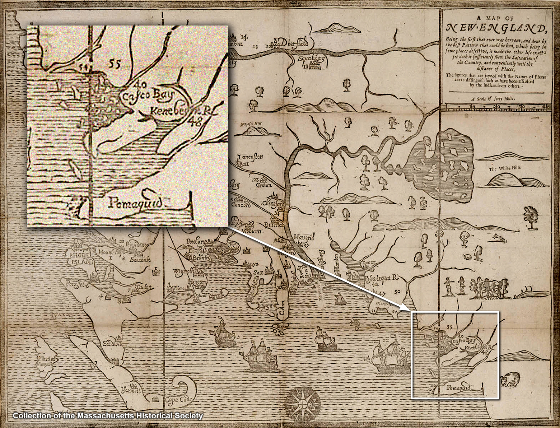
Maps of New England from the 1600s are extremely rare and not very accurate. This map, probably by John Foster, was published in 1677, two years after the beginning of King Philip's War in 1675. The inset shows the "Kenebeck" River and what might be the Androscoggin River (then known as the Pejepscot River) flowing into it, although Merrymeeting Bay itself is not depicted as such in the map.
— Collections of the Massachusetts Historical Society
Later maps and surveys of the Merrymeeting Bay area made during the Pejepscot Proprietor period in the 1700s are more accurate than earlier maps, but land forms and other features are still depicted in a rather inaccurate manner, making it difficult at times to resolve the exact locations of features shown on the maps.
For example, when we encounter a dwelling depicted on a map from this period, we can see that it will require quite substantial "georeferencing" to warp or distort the land forms in the map to match the actual terrain, and even then, the locations of those dwellings are only approximately relative to the land features shown in the map.
For example, if you compare the Androscoggin River as drawn in the 1738 map shown below to a later, accurately drawn map, you can see that it is considerably distorted, even though there are a number of features in the river, such as bends, peninsulas, islands, etc., that correspond to known landscape features.
We have just begun the process of georeferencing old maps to fit actual terrain imagery. This can be a complex process, to which we are applying the use of GIS and various digital imaging tools. We hope to post some georeferenced maps on this website soon.
Effects on the Bay Area Ecology - We are looking at historical sources as well as present-day records describing aspects of the area ecology that may help us learn more about ways in which the early settlers interacted with, and perhaps altered, the Merrymeeting Bay ecosystem by fishing, trading for furs, clearing the land for farming, and by building docks, jetties, and other aids to navigation.
Taken together, we are optimistic that this information will help create a clearer picture of the area ecosystem, which gives us a baseline for comparison to later historic changes in the bay.
By looking at ecological changes over time, possible connections may emerge between human activity and changes in the ecosystem.
Through this process, we hope to gradually add to a body of knowledge that will help us understand what the Merrymeeting Bay area was like in the past, what changes have taken place over time, and how those changes have impacted the local ecosystem. Such information can be extremely valuable for making appropriate land-use planning decisions.
The evidence we find at actual sites may include such things as food remains, eating utensils, etc., that can tell us more about early foodways, as well as tools that tell us how settlers were exploiting the environment by such activities as fishing, farming, stock raising, trading with local Indians, or cutting timber for making barrels, building ships, etc. Locating these lost sites is not an easy task. We will greatly benefit from new sources of evidence for their location.
Obtaining New Evidence - The documentary evidence we have so far only suggests the approximate locations of some of the earliest pioneer sites, and even the later 18th-century sites can be very elusive to find on the ground.
To help us pinpoint the exact locations of these “lost” sites, we are relying largely upon combining our research findings with remote-sensing technologies.
These technologies are important not only for helping us discover the locations of the missing sites but also to determine a number of their characteristics prior to carrying out excavation work.
The upper image is a portion of a 1738 map showing the area where the Androscoggin River meets Merrymeeting Bay. Compared to the modern map below it, it is rather crudely rendered, but some recognizable features can be used to readjust or "georeference" the map to a modern map. We are in the process of georeferencing old maps, and we plan to post the resulting maps on this website.
— Upper image, Collections of Maine Historical Society, courtesy of MaineMemory.net, item 4323.
The most important remote-sensing technology that we are currently relying upon is airborne LiDAR, which can yield very high-resolution imagery that can reveal subtle anthropogenic (human-made) features in the landscape which would otherwise go unnoticed, even to people standing directly on or next to them. For more information about LiDAR and other technologies in our project, see the Technology section.
As our study progresses and we become more involved in site testing and excavation work, there are a number of other technologies that may come into play, depending on several factors such as site characteristics, expected features, and budget. Some of those may include:
- Precessing proton magnetometry
- Ferrous and non-ferrous metal sensing
- Ground-penetrating radar
- Infrared and near-infrared imaging
- Soil resistivity
Gathering and Recording Data - When conducting field work, we strive to gather and record evidence as comprehensively as practically possible, since we believe we have a duty to scholars as well as to the community at large to provide information that will be of importance to a wide range of interests, applications, and areas of research. At the same time, we will also focus attention on gathering data related to certain hypotheses that we develop through our research.
Publication of Findings - We will periodically make general reports on our field work and other research findings on this website, as well as submitting more detailed reports for inclusion in a research-oriented repository. Eventual publication of results in scholarly journals is another possibility as we accumulate and analyze more data.
Note that specific location information for certain sites may be withheld from reports available to the general public at the request of landowners. Reports that are filed in a restricted repository that is only accessible to approved researchers may include more detailed site location information.
Website ©2018, Merrymeeting Bay Pioneers Project